
University city
La Pontificia Universidad Católica del Ecuador se fundó en el año de 1946 contando con 54 estudiantes de jurisprudencia. En el año 1954 se inaugura el campus. Después de 60 años de estar ubicados en el mismo campus, la universidad cuenta con más de 11.000 estudiantes.
El crecimiento universitario hace que el espacio sea insuficiente; así reduciendo las escazas áreas verdes. Por lo que nos vemos obligados a un nuevo campus basado en los principios de la
educación ignaciana y coherente con las exigencias del mundo actual.
Se plantea una ciudad universitaria pensada en el entorno natural y el contexto social.
The Pontifical Catholic University of Ecuador was founded in the year of 1946 with 54 students of jurisprudence. The campus was inaugurated in 1954. After 60 years of being located on the same campus, the university has more than 11,000 students.
University growth means that space is insufficient; thus reducing the scarcity of green areas. So we are forced to a new campus based on the principles of Ignatian education and coherent with the demands of today's world.
It is proposed a university city thought of the natural environment and the social context.


El terreno de la PUCE, sus condiciones topográficas-morfológicas y su entorno natural;
es el punto de partida para desarrollar el trazado de la ciudad universitaria. Y como estrategias generales: reducir el uso del automóvil, desconcentrar las actividades, concebir la ciudad para el peatón, jerarquizar el uso de bicicleta, concentrar los servicios, hacer buen manejo de residuos, hacer uso de energías
alternativas; y la naturaleza debe predominar en el paisaje.
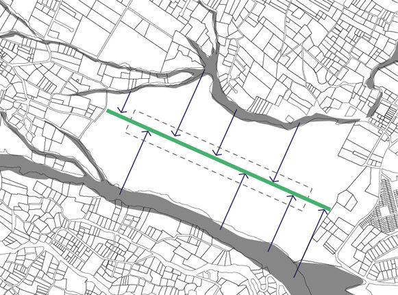
Las quebradas entendidas como accidentes geográficos, son la materialización del paso del tiempo y de fuerzas naturales. Son una estrecha hendidura en las montañas que guían el cauce de riachuelos hacia un rio más caudaloso. Las quebradas también como “vacíos naturales” que configuran la morfología del lugar. Se plantean ejes perpendiculares al de la pendiente; que se adaptan a la topografía. Creando tensión en los límites topográficos y se integran los límites hacia el interior del terreno. Obligando al usuario a entender la realidad natural.
The PUCE's land, its topographic-morphological conditions and its natural environment; was the starting point to develop the layout of the university city. And as general strategies: reduce the use of the car, decentralize activities, conceive the city for the pedestrian, prioritize the use of bicycles, concentrate services, make good waste management, make use of alternative energies; and nature must predominate in the landscape.
The ravines understood as geographical features, are the materialization of the passage of time and natural forces. They are a narrow cleft between the mountains that guide the channel of streams towards a more mighty river. The ravines also as "natural vacuums" that make up the morphology of the place. Axes perpendicular to the slope are proposed; that adapt to the topography. Creating tension in the topographical limits and integrating the limits towards the interior of the land. Forcing the user to understand the natural reality.

Todo el programa universitario se fragmenta en diferentes volúmenes adaptándose a la topografía y se desplazan hacia los límites. A estos volúmenes dispersos en el terreno, los articulamos con un eje que recorre de forma zigzagueante adaptándose a la topografía. Este eje concentra todos los servicios para que la ciudad universitaria funcione. A nivel de suelo está la circulación de peatones y de ciclistas. Sobre columnas se encuentra la vía elevada del tranvia. Los servicios de: recolección de basura, instalaciones electrónicas, eléctricas, agua potable, aguas servidas y aguas lluvia; van soterrados bajo la columna. A través de una red de tubería, que concentra todos los servicios.
The entire university program is fragmented into different volumes adapting to the topography and moving towards the limits. These dispersed volumes in the land, are articulated with an axis that runs in a zigzag way adapting to the topography. This axis concentrates all the services so that the university city works. At the ground level there is the circulation of pedestrians and cyclists. On columns is the elevated track of the tram. The services of: garbage collection, electronic and electrical installations, potable water, sewage and rainwater; they go underground under the column. Through a pipe network, which concentrates all services.


DATOS
Categoría: #Urbanismo #Academia
Tipo: Trabajo de fin de carrera parte 1
Universidad: Pontificia Universidad
Católica del Ecuador
Director de tesis: Arq. Eugene Mangia
Ubicación: Nayón
Fecha: 2014-2015